Mellaria: The Lost Roman Mining City in Córdoba's Sierra
Mellaria hid at Cerro de Masatrigo on the road to Mérida. 2026 University of Córdoba digs reveal its ceramics, aqueduct, road network and river fishing gear.
Art history background with eight years writing interpretive content on Córdoba's Caliphal heritage.
Published
history-buffsphotographersarchitecture
Mellaria never had a temple as grand as Córdoba's, and nobody sells a ticket to see it. It was a working Roman mining town on the road to Mérida, and in 2026 two University of Córdoba studies gave it a level of documentation few rural sites in Roman Hispania ever receive. If you came here looking for opening hours, you're in the wrong place: this is an active excavation near Fuente Obejuna, not a monument with a visitor centre.
Where Mellaria stood: Cerro de Masatrigo and the Sierra Morena
Mellaria stood at Cerro de Masatrigo, about 8 km from present-day Fuente Obejuna, at the point where the N-432 crosses toward El Porvenir in Córdoba's Alto Guadiato comarca[4]. It sits in the northern reaches of the Sierra Morena[9], the mineral-rich range separating the Guadalquivir valley from Extremadura, not in the tourist-mapped city centre 80 km to the south.
The scale of what's buried there is easy to underestimate from the surface. Archaeologists put the walled city at more than 30 hectares, making it the only Roman city in the entire north of the Sierra de Córdoba, roughly 70 km from Mérida[5]. Mellaria organised a surrounding territory known as the Ager Mellariensis, covering some 2,200 km²[6], a mining hinterland rather than a single mine.
Pliny the Elder called the early settlement "not undistinguished" in his Natural History[4]. He also named a second Mellaria, a fish-salting town near the Strait of Gibraltar, in what's now the province of Cádiz[7].
Two Roman towns, one name
Pliny the Elder names two towns called Mellaria. This one is the mining settlement at Cerro de Masatrigo, near Fuente Obejuna in Córdoba province[7]. The other Mellaria was a fish-salting town on the Strait of Gibraltar, near modern Tarifa in Cádiz province[8]. They share nothing but a name.
From Republican outpost to Flavian municipium
Rome founded Mellaria in the mid-2nd century BC, in the years after the Third Punic War, when the Republic pushed its administration beyond the Guadalquivir valley into the Sierra Morena[9]. The move wasn't about farmland. It was about controlling the routes through a region rich in ore, the same roads that would later carry copper, silver and lead out of the wider Sierra Morena mining districts[15].
By 74 AD, the Flavian dynasty had extended Latin municipal rights across Mellaria's territory, turning it into the Municipium Flavium Mellariensium[1]. That status wasn't handed out casually: only two or three cities in the entire Cordoban highlands held it, which says something about how much weight Rome put on a town most modern visitors have never heard of[10].
Part of the answer is logistics. Mellaria sat on the route Roman troops used between Córdoba and what's now Extremadura when campaigning against the Lusitanians, and it worked as a stopover and resupply point on that road[11]. It also supported the mining district around it, including the older La Loba mine nearby[11]. The town organised and provisioned a mining territory; nothing in the record says it worked a mine of its own.
The Via Corduba-Emerita: Rome's highway of metals
Mellaria's real importance was its position on the Via Corduba-Emerita, the road linking Córdoba to Emerita Augusta, modern Mérida, across the Sierra Morena. University of Córdoba researchers have precisely traced 1,160 metres of it running through the town[2], part of a route roughly 213 km, or 144 Roman miles, long. They nicknamed it "the highway of metals", because it carried Sierra Morena's mineral wealth out of the region[12].
The road mattered before Mellaria did. It was the second most important road in the whole of Hispania Baetica during the Republican period, and the only Hispanic road directly linking two provincial capitals; all the copper used to mint coinage at Córdoba and Rome travelled along it[13]. Roman-era road guides, the Antonine Itinerary and the Ravenna Cosmography, list Mellaria alongside Artigis and Metellinum as the three main waypoints between the two capitals[14].
Recommended tours
Tours are selected for quality, not commission. We earn a small fee if you book — at no extra cost to you.
At its height, between the 1st and 2nd centuries AD, three cargoes of real imperial value moved along the road, the most sensitive of them under armed guard[15]:
Copper from Cerro Muriano and the Alto Guadiato
Silver and lead from Los Pedroches
Cinnabar and mercury from the mines of Almadén, ancient Sisapo
Moving any of it was slow work. A heavy-laden cart covered 20-30 km a day, so the full 213 km route took 7-10 days with relief stops at fixed posting stations. Imperial couriers changing horses could cover up to 150 km a day, a speed of communication the peninsula wouldn't match again until the 19th-century railway[16].
Where the metal ended up
Minerals carried along the road were reorganised at Córdoba and shipped down the Guadalquivir, past the city's Roman Bridge, toward Rome. Project director Antonio Monterroso puts it bluntly: without this road, "the capital of Baetica would never have been so rich"[17].
The route itself outlasted the empire's peace. It took shape around the 2nd century BC and endured until at least the 4th century AD; after that its trace disappears entirely, and no medieval or modern road through the Alto Guadiato follows its course[18].
Water, stone and the dead: Mellaria's urban fabric
The 2022-2023 excavation campaigns didn't just map a road. For the first time, they gave researchers a concrete picture of Mellaria's hydraulic system and urban planning, tied directly to the mining exploitation of northwest Córdoba[19]. The same engineering habits show up on a much larger scale in the Roman houses of Colonia Patricia.
In 2023, excavators located the town's castellum divisorium, the point where water was treated and then distributed through the streets via lead pipes[20].
That network started well outside the walls: Mellaria's aqueduct ran 17 km to reach the town[21], engineering no minor settlement would have needed.
The best-preserved fountain in Hispania
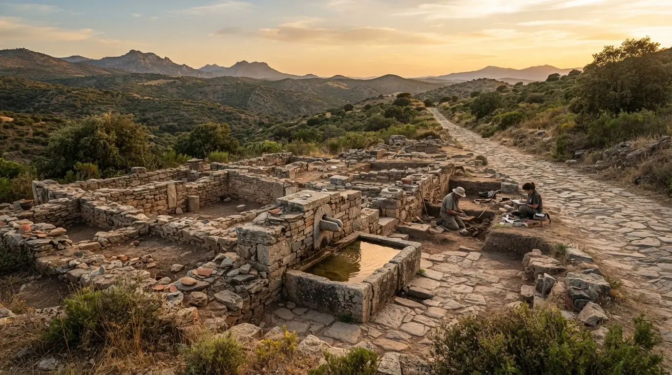
The standout find from the early excavations was a monumental public fountain, or lacus, which project director Antonio Monterroso called "the best-preserved Roman public fountain in all of Hispania"[22]. Per Fuente Obejuna's town hall, it measures roughly 2 metres long and 1.30 metres tall, built from four stone slabs weighing about 1,200 kg each, hauled by mule cart from the Cordoban sierra[23].
Streets, resurfacing and the dead
The road's route through town shaped the city's layout. Archaeologists found the original paving slabs still in place, along with evidence of four successive resurfacings between the 3rd and 5th centuries AD, forming a stratigraphy nearly 2 metres thick[24].
Where the road left Mellaria to the east, following the typical Roman pattern of burying the dead outside the walls, archaeologists documented at least 450 metres of roadway lined with funerary monuments: a 30x30-metre enclosure with a funerary aedicula, fragments of an over-life-size marble statue, and four klinai, the couches used for commemorative banquets in honour of the dead[25].
What the 2026 ceramics study revealed
In May 2026, the University of Córdoba's Ager Mellariensis project published an analysis of 8,839 ceramic fragments recovered during the 2022-2023 campaigns, many of them broken pieces of vessels once used for cooking, storage and trade[3].
The pottery tells its own story of movement and exchange. Some vessels came from as far as Italy, Gaul and North Africa; others were made much closer to home, in workshops at Andújar and Córdoba. Their presence at Mellaria points to merchants and transport networks regularly connecting the town with the rest of Roman Hispania[26].
Comparisons with material from nearby Sisapo revealed striking similarities. Both settlements drew on the same commercial routes and owed much of their development to Sierra Morena's mining districts; the shared pattern in the pottery suggests the two communities' fortunes were closely intertwined[27].
The study was led by UCO professor Antonio Monterroso Checa with Santiago Rodero, also of the University of Córdoba, Maudilio Moreno of the Archaeological Museum of Andújar, and Miriam González of the UNED[28]. Mellaria wasn't an isolated case that year, either: 2026 also brought the discovery of a Roman-era library at Fuente Álamo, elsewhere in Córdoba province, part of a wider run of Roman finds surfacing across the region. Mining had mattered in the area since at least the 2nd century BC, and Mellaria's position between Córdoba and Mérida made it the region's organising town[29].
Timeline
Mid-2nd century BC
Mellaria founded
Rome expands from the Guadalquivir valley into Sierra Morena after the Third Punic War[9]
74 AD
Flavian municipium
Latin rights extended across Mellaria's territory[1]
1st-2nd century AD
Road at its peak
Copper, silver and cinnabar move under military escort along the Via Corduba-Emerita[15]
3rd-4th century AD
A second high point
Mellaria experiences a further peak, its aqueduct still in use[30]
Late 4th century AD
Abandonment
The town disappears with the fall of the Western Roman Empire[30]
Fishing on a mining frontier: the 2026 lead weights
The freshest find is the smallest. In September 2026, researchers published a study of 17 lead fishing weights found near Mellaria, each weighing about 20 grams, flat rectangular pieces of lead in a rolled form[31].
Their size and shape fit small nets used in shallow, slow-moving water. Researchers link them to the iaculum, a casting net worked by a single person, gear well suited to the streams around Mellaria, where larger nets would have been useless[32].
Local fish remains helped the team narrow down what people were actually catching[33]:
Iberian nase
Barbel
Pardilla
Loach
Chub
Jarabugo
Calandino
All are small species suited to light nets in shallow water.
Fishing was never going to rival mining as Mellaria's economic engine, and the researchers say as much. But it mattered for daily food supply, and the 17 weights are physical evidence of a Roman mining community also working its rivers[34]. It's a small addition to a much larger picture, one that runs parallel to other Roman-era discoveries surfacing across the province, including Córdoba's own Roman Temple, found by accident under the City Hall in 1951.
Frequently asked questions
Where was the Roman city of Mellaria?
Mellaria stood at Cerro de Masatrigo, about 8 km from present-day Fuente Obejuna, at the crossing of the N-432 toward El Porvenir, in Córdoba's Alto Guadiato comarca in the northern Sierra Morena[4]. Archaeologists consider it the only Roman city in the entire north of the Sierra de Córdoba, with a walled area of more than 30 hectares[5].
What did Mellaria trade and mine?
Mellaria itself isn't documented as having worked a specific mine. What the sources describe is a town that organised and provisioned a mining region, supporting nearby mines such as La Loba and sitting on the road that carried Sierra Morena's copper, silver, lead and cinnabar out to the rest of the empire[11][15]. Ceramic finds also show it importing pottery from Italy, Gaul, North Africa and Baetican workshops at Andújar and Córdoba[26].
What have archaeologists found at Mellaria recently?
Two 2026 studies from the University of Córdoba's Ager Mellariensis project: in May, an analysis of 8,839 ceramic fragments from the 2022-2023 excavations, documenting the town's hydraulic system and urban planning for the first time[3][19]; in September, a study of 17 lead fishing weights showing residents fished the local streams to supplement their diet[31].
How was Mellaria connected to Córdoba's Roman road network?
Mellaria sat directly on the Via Corduba-Emerita, the road linking Córdoba to Emerita Augusta, modern Mérida. Researchers have precisely traced 1,160 metres of the road through the town, part of a roughly 213 km route researchers nicknamed "the highway of metals" for the mineral wealth it carried out of Sierra Morena[2][12].
Is the Córdoba Mellaria the same as the Roman town near Cádiz?
No. Pliny the Elder names two settlements called Mellaria: this mining town at Cerro de Masatrigo, near Fuente Obejuna, and a separate fish-salting town on the Strait of Gibraltar, near modern Tarifa in Cádiz province[7][8]. They share a name and nothing else.
When did Mellaria become a Roman municipium?
In 74 AD, when the Flavian dynasty extended Latin municipal rights across its territory, creating the Municipium Flavium Mellariensium. Only two or three cities in the entire Cordoban highlands held that status[1][10].
What happened to Mellaria after the Roman Empire declined?
The town reached a further peak in the 3rd and 4th centuries AD, with its aqueduct still in use, before disappearing shortly after the fall of the Western Roman Empire[30]. No medieval or modern route through the Alto Guadiato follows the old Roman road's course[18].
“la Universidad de Córdoba ha identificado con precisión 1.160 metros del trazado de la vía Corduba-Emerita, una de las principales arterias de Hispania.”
“La primitiva aglomeración urbana "no innoble" de Mellaria, como la califica Plinio el Viejo, se ha situado, con razón, en el entorno del Cerro del Masatrigo y el Embalse del arroyo de San Pedro, en el término municipal de Fuente Obejuna.”
“Todo ello es una simple muestra del alto valor urbano de una ciudad que debió alcanzar más de 30 has extensión, al menos intramuros. Se trató de la única ciudad romana en todo el norte de la Sierra de Córdoba, es decir, a unos 70 km de distancia dirección Mérida.”
“Ello, sin duda, le haría ser un considerable centro de organización de todo ese territorio denominado ager Mellariensis y que ocupaba unos 2200km2 de extensión.”
“The city is mentioned in the Natural History written by Pliny the Elder, who references two Mellarias: the one in the Cordoban Beturia, in the municipality of Fuente Obejuna, and another in Cádiz.”
“Mellaria was a Roman settlement in Hispania Baetica, on the coast of the Strait of Gibraltar in what is now the Province of Cádiz in Spain. The fish processing plant is mentioned by Strabo (Geog. 3, 1) under the name Menlaria.”
“It would reach the status of municipium in the Flavian period, and its importance is demonstrated by the fact that only two or three cities held this category in the Cordoban highlands.”
“it was a stopover and resupply point between Córdoba and what is now Extremadura, a route frequently traveled by Roman troops heading to fight the Lusitanians; it also supported the region's mines, such as La Loba, which was founded earlier.”
“los investigadores la han bautizado "la autopista de los metales", porque por ella salía la riqueza minera de Sierra Morena hacia el resto del Imperio.”
“Se trata de la segunda vía de mayor importancia de toda la Provincia Baetica en Época Republicana. Y es la única vía hispana que une directamente dos capitales de provincia. Por ella se transportó todo el cobre que servía para acuñar moneda en Córdoba y Roma.”
“Por el Itinerario Antonino y el Anónimo de Ravenna, dos "guías de carreteras" de época romana, sabemos que la vía que unía las dos capitales romanas del occidente ibérico tenía tres jalones principales intermedios, Mellaria, Artigis y Metellinum, situadas entre ambas ciudades.”
“En su apogeo, entre los siglos I y II d.C., por ella circulaban tres cargas de máximo valor imperial: cobre de Cerro Muriano y el Alto Guadiato, plata y plomo de Los Pedroches, y cinabrio y mercurio de las minas de Almadén, la antigua Sisapo, un mineral tan sensible que su transporte iba escoltado por destacamentos militares.”
“Un carro de carga pesada avanzaba entre 20 y 30 kilómetros diarios, así que recorrer los 213 kilómetros completos exigía 7-10 jornadas con relevos en postas fijas. El correo urgente imperial, cambiando de caballos, cubría hasta 150 kilómetros al día, una velocidad de comunicación que la península no volvería a igualar hasta el ferrocarril del siglo XIX.”
“Esos minerales se reorganizaban en Corduba y bajaban por el Betis —exacto, el Guadalquivir— rumbo a Roma, hasta el punto de que, según Monterroso, sin esta vía "la capital de la Bética nunca hubiera sido tan rica".”
“Esta vía romana se configura en torno al s. II a. C y perdura al menos hasta el s. IV d. C. perdiéndose totalmente su huella con posterioridad a esta fecha. Ninguna vía medieval o actual del Alto Guadiato sigue su recorrido; o al menos no hay pruebas de ello.”
“The work reviews the excavations carried out in the area of Cerro de Masatrigo that offer, for the first time, a concrete view of the hydraulic system of Mellaria and the urban planning of this Roman municipality linked to the mining exploitation of the northwest of Cordoba.”
“Un año después, en 2023, se localizó también el castellum divisorium, el punto donde el agua se potabilizaba y se repartía por la ciudad mediante tuberías de plomo.”
“Las medidas de la fuente (lacus en latín)es de unos dos metros de longitud y de altura tiene 1,30 metros siendo el ancho de 30 centímetros. Cada una de las cuatro losas que la componen pesan 1200 kg y fueron traídas en carros tirados por mulas desde la sierra cordobesa.”
“El trazado urbano de la calzada organiza la forma de la ciudad: se conservan losas del pavimento original y hasta cuatro remodelaciones sucesivas entre los siglos III y V, superpuestas sobre capas de guijarros que forman una estratigrafía de casi dos metros de espesor.”
“Justo donde la vía abandonaba la ciudad por oriente, siguiendo el patrón funerario típico romano de enterrar fuera de las murallas, los arqueólogos han documentado al menos 450 metros de calzada rodeados de monumentos funerarios. Lo encontrado: un recinto de 30 por 30 metros con una edícula funeraria, fragmentos de una estatua de mármol de tamaño superior al natural y hasta cuatro "klinai" —reclinatorios donde celebraban banquetes conmemorativos en honor al difunto—, con un jardín trasero lleno de fosas rituales.”
“Some vessels originated in Italy, Gaul and North Africa, while others were produced much closer to home in workshops at Andújar and Córdoba. Their presence at Mellaria suggests merchants, traders and transport networks regularly connected the town with other parts of Roman Hispania.”
“Comparisons with material from nearby Sisapo revealed striking similarities. Both settlements appear to have drawn on the same commercial routes and both owed much of their development to the mining districts of the Sierra Morena. The shared patterns seen in the pottery suggest that the fortunes of the two communities were closely intertwined.”
“The work was led by UCO professor Antonio Monterroso Checa and carried out together with researchers Santiago Rodero, also from the University of Córdoba, Maudilio Moreno from the Archaeological Museum of Andújar, and Miriam González from the UNED.”
“The town stood in a region rich in metal ores and held a key position between Córdoba and Mérida. Mining became especially important in the area by the second century BCE, while lead objects found at the site show how widely the metal was used.”
“Even in the 3rd and 4th centuries AD, it experienced a peak, only to disappear shortly afterward with the fall of the Western Roman Empire and the subsequent abandonment of the Iberian Peninsula.”
“The weights are small, flat pieces of lead with a rectangular shape and a rolled form. Each weighs about 20 grams. Their size and shape fit small fishing nets used in shallow streams and other waters with little flow.”
“Researchers link the weights to the iaculum, a small net used by one person for fishing. Such gear would have suited the streams around Mellaria, where larger nets would have been less useful.”
“Possible catches included Iberian nase, barbel, pardilla, loach, chub, jarabugo, and calandino. Small fish of these kinds would have suited the use of light nets in shallow water.”
“Fishing appears to have played a smaller role than mining, but researchers argue it still mattered for daily food supply. The 17 weights provide physical evidence for an activity tied to nearby streams and the wider use of the local landscape.”